|
TERMS OF USE:
This free image can only be used for non-commercial, personal
website use only. THIS IMAGE CANNOT BE
used in galleries, downloaded to your computer, posted on sites for
others to use, manipulated, downsized, or upsized. If you are confused about the
terms of use or have any questions then contact us before using the image.
Free Picture: B&B Complex Fires, Oregon
|
Description
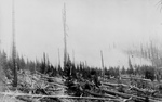
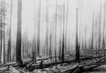
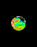
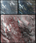
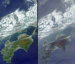
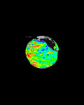
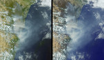
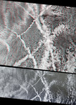
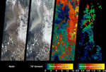
The extent, height, and amount of smoke originating from the B&B Complex Fires in central Oregon are captured in these September 4, 2003 views from the Multi-angle Imaging SpectroRadiometer (MISR). When the data were acquired, the Booth and Bear Butte Fires had been underway for 16 days and had consumed about 70,000 acres near Sisters, Oregon. Although a distinct plume rises from the location of the Bear Butte Fire (just northwest of the larger Booth Fire), the fire-lines had merged together by this time and became known as the B&B Complex. Centered in the Deschutes and Willamette National Forests, the blazes in these mixed-conifer old-growth forests were aided by earlier dry conditions and fed by heavy fuel loads, regeneration timbers, and large tracts of beetle-killed dead woods. The left and center-left panels are natural-color images from MISR's vertical-viewing (nadir) and most obliquely forward-viewing (70-degree) cameras, respectively. The appearance of smoke and haze is enhanced at the more oblique view. The center-right panel is a height field for features exhibiting sufficient spatial contrast for their elevations to be retrieved by MISR's automated stereo algorithm. The results indicate that the tops of the two main plumes originating from the B&B complex differ in altitude by about 1-2 kilometers. At right is a map of aerosol optical depth, a measure of the amount of aerosol particles present within the atmospheric column. In the central portion of the plume, the smoke was too thick for MISR's automated optical depth retrieval algorithm to work, and over these areas or locations where clouds or other factors precluded a retrieval the map is colored black.
Keywords
b and b complex fires, bb complex fires, bear butte fires, booth and bear butte fires, booth fire, deschutes and willamette national forests, deschutes national forest, earth science, environment, environmental, jpl, nasa, oregon, oregon fires, plumes, smoke plume, smoke plumes, willamette national forest, smoke, free photography, free photo, free photos, free picture, free pictures, free image, free images
|
Similar Free environment Pictures
|
|
|
|