|
TERMS OF USE:
This free image can only be used for non-commercial, personal
website use only. THIS IMAGE CANNOT BE
used in galleries, downloaded to your computer, posted on sites for
others to use, manipulated, downsized, or upsized. If you are confused about the
terms of use or have any questions then contact us before using the image.
Free Picture: Southern California
|
Description
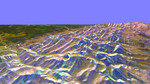
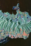
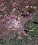
Image showing detail of the varied topography of Southern California. The large V-shape across the center of the image is the intersection of the mountains uplifted along two major faults. The San Andreas Fault is the lower part of the "V" and the Garlock Fault is the upper part. Between the faults is the western Mojave Desert, including the alternate landing site for the Shuttle at Edwards Air Force Base, near the center of the image. The Pacific Coast appears in the lower left of the image, from Oxnard at the left center edge, curving southeast to Los Angeles. The flat blue area along the top is the southern end of California's Central Valley. Along the right edge of the image is NASA's Goldstone Deep Space Tracking Station.
Keywords
ca, calif, california, californias central valley, central valley, earth science, fault, faults, garlock fault, geography, jpl, mojave desert, san andreas fault, so california, southern california, nasa, free photography, free photo, free photos, free picture, free pictures, free image, free images
|
Similar Free geography Pictures
|
|
|
|