|
TERMS OF USE:
This free image can only be used for non-commercial, personal
website use only. THIS IMAGE CANNOT BE
used in galleries, downloaded to your computer, posted on sites for
others to use, manipulated, downsized, or upsized. If you are confused about the
terms of use or have any questions then contact us before using the image.
Free Picture: California
|
Description
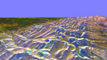
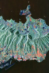
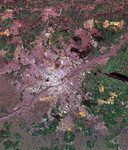
This topographic image vividly displays California's famous San Andreas Fault along the southwestern edge of the Mojave Desert, 75 kilometers (46 miles) north of downtown Los Angeles. The entire segment of the fault shown in this image last ruptured during the Fort Tejon earthquake of 1857. This was one of the greatest earthquakes ever recorded in the U.S., and it left an amazing surface rupture scar over 350 kilometers in length along the San Andreas. Were the Fort Tejon shock to happen today, the damage would run into billions of dollars, and the loss of life would likely be substantial, as the communities of Wrightwood, Palmdale, and Lancaster (among others) all lie upon or near the 1857 rupture area. The San Gabriel Mountains fill the lower left half of the image. At the extreme lower left is Pasadena. High resolution topographic data such as these are used by geologists to study the role of active tectonics in shaping the landscape, and to produce earthquake hazard maps.
Keywords
ca, calif, california, fault, faults, geography, jpl, lancaster, mojave desert, palmdale, pasadena, radar image, radar images, san andreas fault, san gabriel mountains, san gabriel mtns, nasa, free photography, free photo, free photos, free picture, free pictures, free image, free images
|
Similar Free geography Pictures
|
|
|
|