|
TERMS OF USE:
This free image can only be used for non-commercial, personal
website use only. THIS IMAGE CANNOT BE
used in galleries, downloaded to your computer, posted on sites for
others to use, manipulated, downsized, or upsized. If you are confused about the
terms of use or have any questions then contact us before using the image.
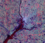
Free Picture: St. Louis, Missouri
|
Description
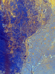
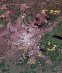
Image of St. Louis, Missouri from space. This is a spaceborne radar image of the area surrounding St. Louis, Missouri, where the Mississippi and Missouri Rivers come together. The city of St. Louis is the bright gold area within a bend in the Mississippi River at the lower center of the image. The rivers show up as dark blue sinuous lines. Urbanized areas appear bright gold and forested areas are shown as a brownish color. Several bridges can be seen spanning the river near downtown St. Louis. The Missouri River flows east, from left to right, across the center of the image, and meets the Mississippi River, which flows from top to bottom of the image. A small stretch of the Illinois River is shown at the top of the image where it merges with the Mississippi. The Mississippi forms the state boundary between Illinois (to the right) and Missouri (to the left). Flat farmland areas within the river floodplains appear blue on the image. The major roadways that pass through the area can be seen radiating out from, and encircling, the city of St. Louis. These highways, the rivers and the bridges help maintain St. Louis' reputation as the "Gateway to the West.
Keywords
from space, geography, illinois river, jpl, mississippi river, missouri, missouri river, st louis, st louis from space, st louis missouri, st louis missouri from space, view from space, nasa, free photography, free photo, free photos, free picture, free pictures, free image, free images
|
Similar Free geography Pictures
|
|
|
|