|
TERMS OF USE:
This free image can only be used for non-commercial, personal
website use only. THIS IMAGE CANNOT BE
used in galleries, downloaded to your computer, posted on sites for
others to use, manipulated, downsized, or upsized. If you are confused about the
terms of use or have any questions then contact us before using the image.
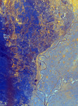
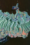
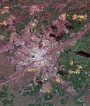
Free Picture: Sacramento, California
|
Description
Radar image of the city of Sacramento from space. Urban areas appear pink and the surrounding agricultural areas are green and blue. The Sacramento River is the curving dark line running from the left side of the image (northwest) to the bottom right. The American River is the dark curving line in the center. Sacramento is built at the junction of these two rivers and the state Capitol building is in the bright pink-white area southeast of the junction. The straighter dark line (lower center) is the Sacramento River Deep Water Ship Channel which allows ship access from San Francisco. The black areas in the center are the runways of the Sacramento Executive airport. The city of Davis, California is seen as a pink area in lower left.
Keywords
american river, ca, cali, calif, california, davis, davis california, from space, geography, jpl, sacramento, sacramento california, sacramento executive airport, sacramento from space, sacramento river, sacramento river deep water ship channel, view from space, nasa, free photography, free photo, free photos, free picture, free pictures, free image, free images
|
Similar Free geography Pictures
|
|
|
|