
|
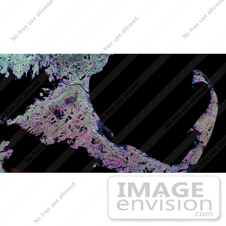
NASA radar image of the hook of Cape Cod, Massachusetts. The Cape, which juts out into the Atlantic Ocean about 100 kilometers (62 miles) southeast of Boston, actually consists of sandy debris left behind by the great continental ice sheets when they last retreated from southern New England about 20,000 years ago. Today's landscape consists of sandy forests, fields of scrub oak and other bushes and grasses, salt marshes, freshwater ponds, as well as the famous beaches and sand dunes. In this image, thickly forested areas appear green, marshes are dark blue, ponds and sandy areas are black, and developed areas are mostly pink. The dark L-shape in the lower center is the airport runways in Hyannis, the Cape's largest town. The dark X-shape left of the center is Otis Air Force Base. The Cape Cod Canal, above and left of center, connects Buzzards Bay on the left with Cape Cod Bay on the right. The northern tip of the island of Martha's Vineyard is seen in the lower left. The tip of the Cape, in the upper right, includes the community of Provincetown, which appears pink, and the protected National Seashore areas of sand dunes that parallel the Atlantic coast east of Provincetown. Scientists are using radar images like this one to study delicate coastal environments and the effects of human activities on the ecosystem and landscape. Photo Credit: NASA/JPL [0003-0701-1019-1633] by 0003
|
Keywords
atlantic ocean, buzzards bay, cape, cape cod, cape cod bay, cape cod canal, cape cod from space, cape cod massachusetts, from space, geography, hook of cape cod, hyannis, jpl, marthas vineyard, massachusetts, nasa, national seashore, otis air force base, provincetown, view from space
|
|


